


Run Montat

cps46
User
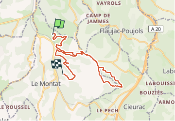

Length
17.5 km

Max alt
290 m

Uphill gradient
514 m
Km-Effort
24 km

Min alt
178 m

Downhill gradient
468 m
Boucle
No
Creation date :
2024-03-09 08:58:22.0
Updated on :
2024-03-09 11:38:32.667

FREE GPS app for hiking
 SityTrail
IGN / Geographical institutes
SityTrail Plus
The world is yours!
About
Trail of 17.5 km to be discovered at Occitania, Lot, Le Montat. This trail is proposed by cps46.
Positioning
Country:
France
Region :
Occitania
Department/Province :
Lot
Municipality :
Le Montat
Location:
Unknown
Start:(Dec)
Start:(UTM)
376646 ; 4918004 (31T) N.
Comments